Quick Links
Community Mission
The K-12 STEM (Science, Technology, Engineering, and Mathematics) Outreach Community of Interest’s mission is to promote and support pathways to STEM degrees and STEM careers for K-12 students as part of the national strategic effort to produce more STEM professionals for the nation.
Join the SAME Engage K-12 STEM Outreach NetworkVision
The K-12 STEM Outreach Committee provides for the security of the nation by ensuring a robust STEM workforce.
Scope
K-12 students need to be exposed to STEM activities, degrees, and careers as they move up the academic ladder. The committee will work with the network of Posts, individual members, sustaining members, service branches, and strategic partners to increase opportunities for STEM exposure for K-12 students. The COI will also promote the Society’s STEM programming at local, regional, and national events, as resources allow.
Activities
- Categorize different examples of how the Post/individuals support K-12 STEM at the local level
- Identify and provide guest speakers/webinars on relevant topics
- Serve as a clearinghouse of STEM information
- Provide a calendar of STEM (SAME/Post and external) events and points of contacts
To learn more about the K-12 STEM Outreach Community of interest, contact a member of the Steering Committee, or reach out to Amy McGeever, STEM Coordinator.

Community Chair
Victoria Hernandez
Program Manager, AFCEC

Immediate Past Community Chair
Joshua Graham, P.E., PMP, F.SAME
Project Manager, HDR
Vice Chair, Strategic Alliance: Jeffrey Leonard, PE, CFPS, F.SAME
Vice Chair Programs: Lexi Lessaris
Vice Chairs, Communications and Outreach: Zayda Shavkatova and Roger Minyami
Vice Chair, Awards and Recognition: Traci Dewar
Upcoming National Webinars
-

- Webinar
Solving Complex CVOC Problems with ISTR– Field Proven Approaches
This webinar will first discuss the unique aspects of performance-based designs when considering procurement of thermal remediation services. Next, we will discuss how to evaluate criteria when selecting performance objectives, i.e., “ how do you define success?” -

- Webinar
The National Spatial Reference System: Modernizing Our Geodetic Foundation for the Future
The National Geodetic Survey (NGS), within the National Oceanic and Atmospheric Administration (NOAA), is in the process of making the critical transition from the current National Spatial Reference System (NSRS) to the upcoming, modernized (2022) system. -

- Webinar
CMMC Level 2: What A/E Firms Must Know Before November
Starting November 10, 2026, the Department of Defense will require CMMC Level 2 certification for contractors handling Controlled Unclassified Information (CUI). Unlike prior self-attestation requirements, this mandate requires verification by an accredited third-party assessor before a firm can be awarded or retain applicable DoD contracts.


Related TME Articles – K-12 STEM Outreach
-

Managing Mission Readiness for Our Military
Looking Forward presented by Jacobs. In a continually changing world, today’s military is under more pressure than ever to operate efficiently and cost-effectively. Leadership also must balance the need to keep an eye on the future as it relates to cyber threats, energy security, and sustainability. -
Building a Common Operating Picture of Facilities, Infrastructure, and Terrain
With an increasing need for commanders to have an understanding of infrastructure and the physical environment both on and off the battlefield, geospatial engineers must be able to provide a global, holistic, and cohesive view through tools like the Joint Engineer Common Operating Picture. -
Meeting Data-Intensive Challenges With Narrow AI
When considering solutions for targeted, data-intensive problems, such as a recent challenge undertaken by the Air Force Civil Engineer Center to predict construction project priorities, the use of traditional narrow artificial intelligence still beats emerging technologies. -
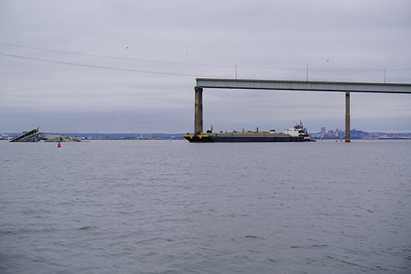
Leveraging Geospatial Data Tools on the Key Bridge Response
In carrying out the joint response after the Key Bridge collapse, the U.S. Coast Guard and other partner agencies leveraged both internal and external geographic information system expertise to provide data-sharing and near real-time monitoring capabilities.