Leveraging 3D Scanning on Archaeological Sites
By Kaitlyn Kingsland, Ph.D., M.SAME
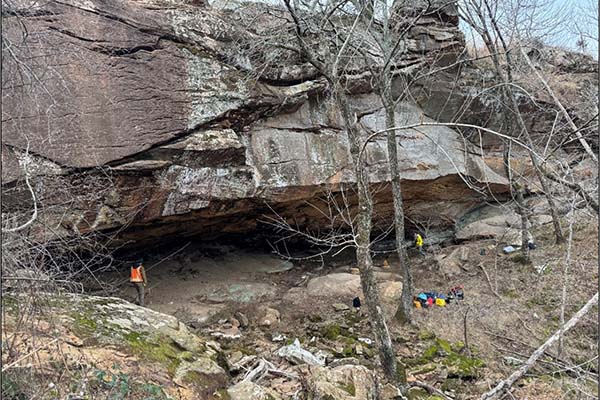
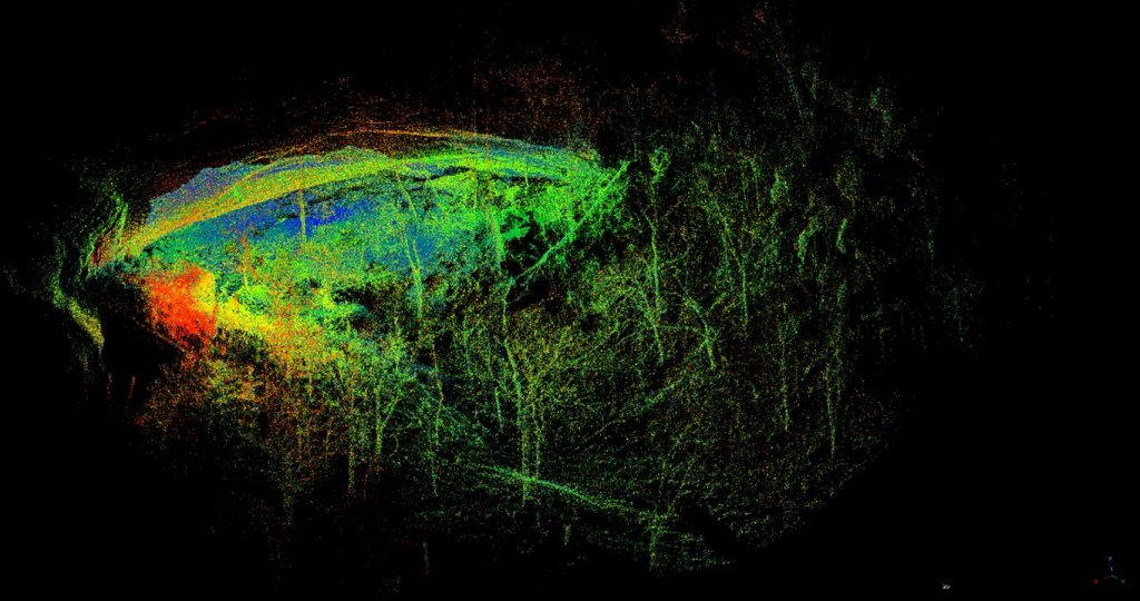
To better preserve an archaeological rockshelter in eastern Oklahoma on the Osage Nation, an environmental team turned to LiDAR and photogrammetry, conducting precise damage assessment and enabling long-term monitoring.
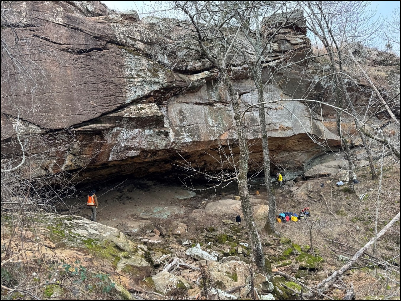
for accurate analysis of erosion and looter impacts. Photos courtesy ERG-Terracon JV LLC.
From the integration of photography to computer-aided design and drone-based surveying, engineering disciplines long have embraced new technologies as their utility is proven. Just as previous innovations have been adopted in the past, new waves of tools become increasingly relevant and common in practice. What starts through research and development, then emerges from pilot studies, eventually becomes standard operating procedure.
The current engineering advancements are heavily leveraging LiDAR, 3D scanning, and digitization. As these once-novel capabilities proliferate, they also facilitate the introduction and more widespread use of digital twins (highly accurate virtual copies of an environment or object that exists in the physical world). Digital twins can assist with measuring, designing, and developing building information models. They can support compliance and monitoring, such as structural inspections at a large scale; laydown and planning for major systems overhauls; failure analysis of vital components; or fabrication of obsolete parts that cannot be removed from service.
Recently, these technologies were deployed in the preservation and protection of an archaeological site in eastern Oklahoma, a project contracted to Environmental Research Group and Terracon Joint Venture (ERG-Terracon JV LLC) in coordination with the Osage Nation and the Tulsa District of the U.S. Army Corps of Engineers.
The roof of the rockshelter serves as a major runoff location during rainstorms. This makes the area surrounding it prone to natural erosion.
Virtual Models
Digital twins are created by 3D scanning and digitization methods, including LiDAR and digital photogrammetry. LiDAR methods create a highly accurate and precise point cloud, which can contain hundreds, thousands, or millions of measured points in 3D space. Distance is determined by the time it takes for a scanned laser pulse to emit and bounce off a surface and back to the scanner. Most commonly, these point clouds allow for rapid measurements of a space that can then be utilized in computer-aided design programs or a building information model.
Alternatively, digital photogrammetry uses a series of overlapping photos to build a 3D model. This method can produce highly accurate and precise digital twins, although specific steps must be taken to guarantee measurement quality. Digital photogrammetry excels at creating a color-accurate 3D model that users easily navigate, while also being computationally lighter in comparison to LiDAR-based digital twins. Both techniques can be used in tandem or separately; preference depends on project needs.
Other types of digitization methods and technologies can create digital twins, such as structured-light scanning and various forms of laser scanning. Every digitization approach comes with benefits and compromises that need to be weighed against project goals.
Digitizing Benefits
While it was possible to complete the environmental preservation and protection work on the Osage Nation site using traditional measurement methods, creating a digital twin has provided additional benefits that are not possible using analog tools.
Using LiDAR scans, volumetric analysis can be more comprehensive and precise. At the rockshelter site, the volume of soil removed by looters pits was used to determine costs; as a result, it was crucial to be as precise as possible in calculating their size and depth. By using a specific type of LiDAR, the accuracy for measurements can be up to a .25-in (about 6-mm) per scan. This allows the final point cloud to be created with minimal time on-site and with higher levels of certainty when compared to traditional measurement tools. In addition, digital tools allow for precise volumetric calculations that account for different depths and irregular shapes.
The digital twin provides a lasting time capsule of how a site looked at the time of scanning. In some cases, environmental factors like excessive rainfall or earthquakes can damage locations beyond recognition. In that case, the digital twin serves as a highly accurate copy of the site that can exist in perpetuity.
The digital twin also makes “visits” possible from essentially anywhere, bringing the site back to the stakeholders virtually and giving others a chance to “visit” the site when such opportunities would not be available otherwise due to access or proximity.
Precise Protection
To conduct the cultural resource work in Oklahoma, the joint venture utilized LiDAR and digital photogrammetry. The technologies helped in determining the amount of damage that erosion and looting had caused to a rockshelter (a space situated beneath a rock overhang) and helped monitor for future potential damage.
The site is located on an extremely steep, gravelly hillside. The roof of the rockshelter serves as a major runoff location during rainstorms. This makes the area surrounding it prone to natural erosion. In addition, the rockshelter is located near a public park. While difficult to access, passersby can still find their way to the area, which may lead to damage due to a lack of awareness concerning looting laws and land ownership rights, as well as potentially being uninformed about its important history.
The project team developed a digital twin to get a better understanding of the site and show its current condition. New scans can be taken in the future and compared to this baseline in order to analyze erosion and human impacts, with greater precision and detail than through traditional methods alone.
Site Preservation
The digital twins created for the Osage Nation archaeological site highlight a real-world scenario where LiDAR and digital photogrammetry are being harnessed to solve that would have been more difficult or cost-prohibitive using traditional analog tools.
The collaborative effort also underscores the practicality of new ways to interact with historically significant sites and facilitate future research, analysis, and preservation initiatives.
Evolving Adoption
The application of LiDAR and other 3D scanning methods, such as photogrammetry, especially in coordination with drones, provides exciting new deliverables and ways to complete environmental-related work.
The turn toward digital tools in engineering-related work has been gradual over the last few decades. Increasingly, however, students are being exposed to digital twins in particular. Industry conferences are buzzing with how to use digitization to streamline and enhance work products and goals. The application of digital twins in the environmental industry has become a consideration for many projects and analysis of both the natural and built environments.
The benefits of digitization in the environmental industry include increased accuracy in monitoring, planning and design, and mitigation efforts.
Kaitlyn Kingsland, Ph.D., M.SAME, is Program Manager of Innovation and Technology, Environmental Research Group LLC; kaitlyn.kingsland@envrg.com.
Published in the January-February 2026 issue of The Military Engineer
Check Out Related Articles From TME
-

Innovative PFAS Remediation at Camp Grayling
For project stakeholders and remediation managers confronted with PFAS, Regenesis demonstrates the efficacy of using Regenesis’ PlumeStop® colloidal activated carbon (CAC) at Camp Grayling, Michigan. -
A Standardized Approach to Aircraft Fire Training Infrastructure
To support enterprise-wide airmen readiness, the U.S. Air Force is modernizing its standard design for aircraft fire training facilities—introducing digital controls, dual-fuel systems, and PFAS-conscious infrastructure. -
Delivering Energetic Materials Manufacturing Facilities
Designing and constructing facilities that manufacture, process, handle, or store explosives and energetic materials present some of the most challenging defense projects—requiring technical experience, strict safety protocols, and a comprehensive understanding of regulatory frameworks. -
Forging Tradition and Innovation: A New Design Standard at Camp Lejeune
The II MEF Headquarters at Camp Lejeune blends Georgian Revival architecture with modern sustainability—delivering durability, efficiency, and precision that meets contemporary functional requirements while honoring heritage. -

Balancing Efficiency and Fiscal Responsibility
The continuing contracts clause offers the U.S. Army Corps of Engineers a way to improve project delivery and enhance fiscal responsibility by aligning funding with project execution. -
Next Steps for Digital Twin Development
U.S. Forces Japan is laying the groundwork for future integration of digital twin technology in order to validate and collect data that will offer comprehensive insights into utility conditions at installations and enhance overall decision-making, efficiency, and resilience.