Scaling AI to Support Wildfire Debris Recovery
By Prashant Jadiya, M.SAME
To support debris removal operations following the 2025 Los Angeles wildfires, an AI-assisted approach initially used as part of wildfire recovery efforts in Maui was scaled up for parcel-level vehicle detection across a larger, more complex debris removal environment.
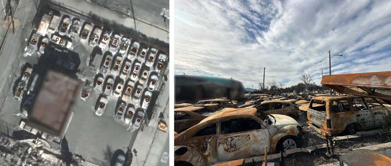
Following the 2025 Los Angeles wildfires, ground validation provided the key essential link between AI detections and real-world conditions, ensuring vehicle impact assessments were accurate and defensible. Photos courtesy ECC.
Recovery efforts after a wildfire begin long before a truck enters a burned neighborhood. For debris removal teams, early questions are deceptively simple: what is on each property, and what must be planned for before field work begins? In dense urban fire environments, vehicles are more than objects in an image. Their presence and condition affects safety, access, hazardous material handling, scheduling, and sequencing.
In early 2025, as wildfire damage across Los Angeles County prompted urgent needs for debris removal planning, a data science team with ECC began developing an AI-assisted approach to support situational assessment. The goal was not to replace field judgment—it was to help planners work from a consistent, parcel-level view of conditions, using high-resolution satellite imagery and computer vision to identify likely vehicle locations.
Proven Workflow
In a burned urban environment, where fences, driveways, and structure footprints may no longer be visually clear, the geospatial boundary became the operational reference. In fact, a key lesson is that AI accuracy cannot be evaluated apart from the geospatial inputs that frame the decision.
The response effort in Los Angeles grew from work completed during the devastating 2023 wildfires that ravaged Maui. There, in support of the U.S. Army Corps of Engineers and Federal Emergency Management Agency, ECC had used AI-driven vehicle detection across an operational environment of 1,350-acres—achieving 99.6 percent accuracy in a focused application. Among the lessons learned, the survey team determined that model performance depends as much on geospatial discipline, image quality, and validation as on model architecture. That project provided a practical baseline: detect objects of operational interest, tie them to the correct property, and communicate results clearly.
Los Angeles presented a more complex problem. The footprint was massive, more than 57,500-acres. The scope of work included over 18,000 structures and relied on 350-GB of high-resolution imagery drawn from three sources. Compared with Maui, the area was nearly 40 times larger and far less uniform. It was clear early on that the model from Maui could not simply be reused in Los Angeles. It was, however, a proven workflow that could be expanded, tested and hardened under greater operational pressure.
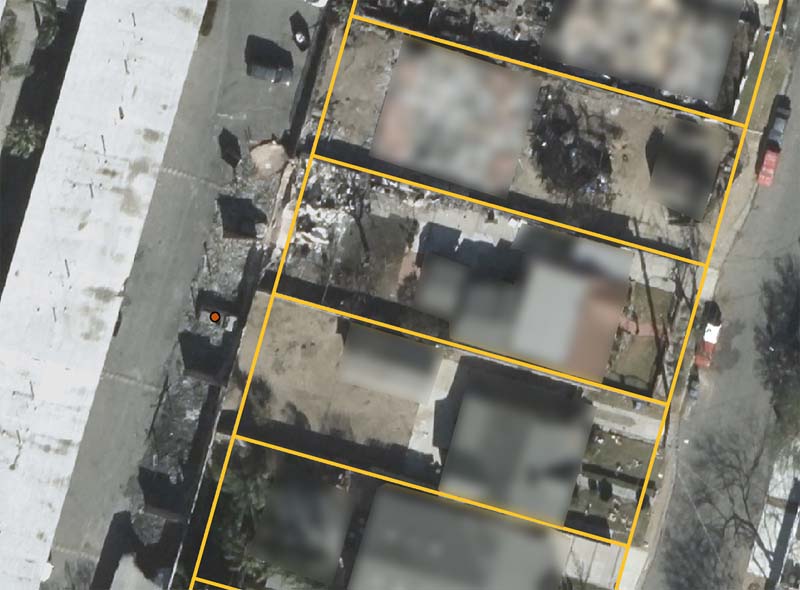
Parcel-level analysis limited vehicle detections to property boundaries, helping convert imagery outputs into useful planning information.
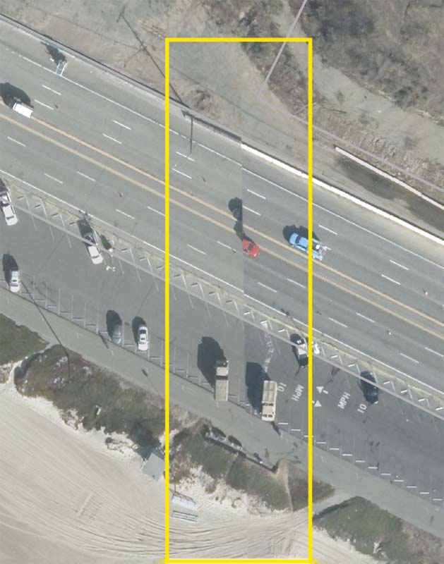
Imagery from satellite sources varied in resolution, alignment, viewing angle, lighting and capture timing, which created challenges for parcel-level analysis.
Images to Decisions
While the technical objective of the project was straightforward, to detect vehicles in post-fire imagery and assign detections to individual parcels, that simplicity was deceptive.
- Imagery came from different satellites and varied in resolution, collection angle, lighting, shadowing, smoke effects, and capture timing.
- Fire damage changed the visual context around every object. Vehicles could appear burned, partially covered, adjacent to debris, or obscured by tree shadows and structural remains.
- For operations, a detection outside a parcel boundary, even by a small margin, could produce the wrong planning assumption.
The data pipeline treated AI as a single component of a larger geospatial system. Imagery was ingested, aligned to a common working grid, subdivided into manageable tiles, and processed through object-detection models. Detections were filtered, assigned confidence scores, and spatially joined to parcel boundaries. This step was critical. The analysis was limited to the area inside each property, so parcel image quality directly influenced the usefulness of every result.
Defining the Area. The first major challenge in Los Angeles was defining the area of interest. Specificity is central to the overall process because disaster recovery planning is property-specific. Any vehicles located in streets, alleys, neighboring parcels, or public rights-of-way may appear visually similar to cars or trucks located inside an assigned work area, but they should not be counted the same way. The ECC team built its workflow around parcel boundaries and enforced a strict rule: only detections within the property boundary were eligible for parcel-level counts.
This mandate required careful quality control. Parcel files had to be complete, spatially accurate, and consistent with the imagery. In a burned urban environment, where fences, driveways, and structure footprints may no longer be visually clear, the geospatial boundary became the operational reference. In fact, a key lesson is that AI accuracy cannot be evaluated apart from the geospatial inputs that frame the decision.
Imperfect Imagery. The second challenge was multi-source imagery. In controlled demonstrations, computer vision models often operate on consistent imagery. Rarely does disaster response offer that advantage. For Los Angeles, imagery varied across source, date, resolution, viewing geometry, and lighting. Small shifts in alignment could change whether a vehicle appeared inside or outside a parcel. Differences in collection angle could make the same object look longer, shorter, or partially hidden.
The team also experimented with burned tree detection as a potential additional analytics layer. This proved less reliable than vehicle detection because the available satellite imagery did not consistently support visual separation between burned trees, dark vegetation, debris, and tree shadows. In many cases, shadow patterns and post-fire vegetation signatures appeared too similar from overhead imagery. The experiment reinforced an important lesson: not every object class is suitable for automated detection unless image quality, resolution, and visual separability are strong enough to support defensible results.
To manage this variable, the team used a review process that combined automated detection with spatial sanity checks and sample-level human validation. Any detections made near parcel edges received special attention because they were most sensitive to alignment error. Model confidence thresholds were evaluated carefully. At a 90 percent confidence threshold, the model achieved 71 percent precision and 68 percent recall. At a stricter 95 percent threshold, precision increased to more than 78 percent, with an 8 percent reduction in recall. Higher precision reduced false positives. Higher recall identified more potential vehicles for planning.
Speed to Visibility. The third challenge was time. Development of the models began simultaneously with project planning and moved under compressed timelines. This created a different kind of engineering problem. The team could not wait for a perfect dataset, a fully mature labeling environment, or unlimited model tuning. It had to build a repeatable process quickly while making uncertainty visible.
That meant adopting an operationally honest approach to AI. Outputs were not presented as absolute truth. They were treated as decision-support information: predicted vehicle ranges, confidence-based detections, parcel-level summaries, and validation results. This allowed planners to use the information appropriately while retaining field verification and human judgment.
Validating Results
Throughout the project, validation was essential. The team compared model predictions against ground-level observations and sample imagery from affected properties. Where ground reference photos showed burned vehicles or vehicle remains, corresponding satellite imagery and detection outputs were reviewed. Across multiple locations, detected vehicles aligned closely with observed conditions, including in areas with heavy damage, variable visibility, and inconsistent image quality.
This validation process did more than produce accuracy metrics. It helped in understanding failure modes. Some false positives were caused by debris piles, roof remnants, shadows, or vehicle-like shapes. Other times, detections were missed that involved burned vehicles with reduced visual contrast or partial occlusion. Documenting these cases helped tune thresholds, improve review protocols, and communicate limitations transparently.
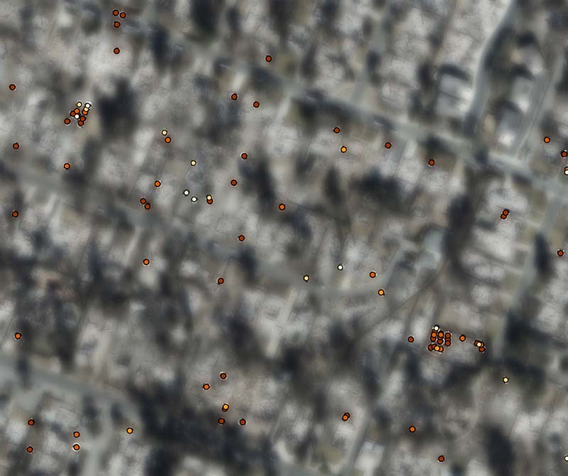
Vehicle detections were assigned confidence scores and spatially joined to parcel boundaries to support planning and prioritization.
Compared with Maui, the area was nearly 40 times larger and far less uniform.
Practical Models
Several lessons emerged during the Los Angeles wildfire response.
- First, model development must begin with the operational question, not the algorithm. For disaster recovery, the relevant unit is often not an image tile but a parcel, road segment, facility, or work package.
- Second, geospatial accuracy is as important as visual detection accuracy. A correct detection mark assigned to the wrong property can create operational confusion. The issue often is not what the AI can see, but where it is looking.
- Third, confidence thresholds should be selected based on the intended decision. A planning screen may tolerate different error types than a clearance record or compliance report.
- Fourth, validation must combine metrics with field context. Precision and recall are necessary, but they do not tell the full story unless analysts understand why errors occur and how those errors affect operations.
- Finally, AI adoption depends on trust—and that is earned through transparent methods, defensible validation, and clear communication about uncertainty.
As disasters become more complex, population centers and economic hubs acutely affected, and recovery timelines more compressed, response teams will need faster ways to transform imagery into actionable information. The adoption of AI can help, but only when it is implemented as part of a disciplined operational workflow. The wildfire debris removal in Los Angeles showed that AI can support parcel-level situational assessment at scale when combined with quality data, geospatial rigor, ground-truth validation, and human oversight.
For emergency management and engineering organizations, the path forward is not to treat AI as a replacement for field expertise. It is to use the technology to focus that expertise where it is needed most. From Maui to Los Angeles, the evolution of wildfire analytics demonstrates a practical model for disaster response: start with a real operational need, build from proven experience, validate against the field, and scale only when the results are credible enough to support decisions.
Operational Value
The immediate value of the AI-assisted workflow was planning. Parcel-level vehicle estimates helped inform debris removal sequencing, resource allocation, and prioritization. Across the impacted regions, predicted vehicle ranges provided an early, consistent view of conditions before crews completed all field observations. ECC ultimately removed more than 6,500 vehicles from affected properties, demonstrating that the analytical problem was tied directly to field operations, safety, and recovery progress.
The broader value was institutional learning. The recovery effort at Maui showed that AI could detect vehicles accurately in a wildfire recovery environment. Los Angeles showed that the capability could scale when paired with geospatial controls, validation, and operational discipline. The most important result was not a single model score, but a repeatable framework for using AI responsibly in disaster response.
Prashant Jadiya, M.SAME, is Data Science Manager, ECC; pjadiya@ecc.net.
Published in the September-October 2026 issue of The Military Engineer

Check Out Related Articles From TME
-

Innovative PFAS Remediation at Camp Grayling
For project stakeholders and remediation managers confronted with PFAS, Regenesis demonstrates the efficacy of using Regenesis’ PlumeStop® colloidal activated carbon (CAC) at Camp Grayling, Michigan. -
A Standardized Approach to Aircraft Fire Training Infrastructure
To support enterprise-wide airmen readiness, the U.S. Air Force is modernizing its standard design for aircraft fire training facilities—introducing digital controls, dual-fuel systems, and PFAS-conscious infrastructure. -
Delivering Energetic Materials Manufacturing Facilities
Designing and constructing facilities that manufacture, process, handle, or store explosives and energetic materials present some of the most challenging defense projects—requiring technical experience, strict safety protocols, and a comprehensive understanding of regulatory frameworks. -
Forging Tradition and Innovation: A New Design Standard at Camp Lejeune
The II MEF Headquarters at Camp Lejeune blends Georgian Revival architecture with modern sustainability—delivering durability, efficiency, and precision that meets contemporary functional requirements while honoring heritage. -

Balancing Efficiency and Fiscal Responsibility
The continuing contracts clause offers the U.S. Army Corps of Engineers a way to improve project delivery and enhance fiscal responsibility by aligning funding with project execution. -
Next Steps for Digital Twin Development
U.S. Forces Japan is laying the groundwork for future integration of digital twin technology in order to validate and collect data that will offer comprehensive insights into utility conditions at installations and enhance overall decision-making, efficiency, and resilience.