
Community Mission
Expand awareness and leveraging of geospatial engineering for operational effects.
Community Chair
Scott Ensign, GISP
MSgt, Ret, USAF, Air Force Civil Engineer Center
Organization Structure
Immediate Past Chair: David Foster, Lt Col, USA, Ret., 372 Consulting, LLC
GeoWERX Coordinator: Dan Mummert, PE, Pickett and Associates, LLC
- Geospatial Working Group Presentation, Frontier Post, 26 October 2023
- Small Business Conference, 1-3 November 2023
- Geospatial Working Group Lunch
- Joint Engineer Training Conference & Expo, 14-16 May 2024
- Geospatial Engineering SummitGeoWERX ‘24
- Annual Geospatial Working Group Meeting
Mission: Expand awareness and leveraging of geospatial engineering for operational effects.
Why: Build awareness and deployment of people, processes, and tools to create the digital foundation for engineering better outcomes across basing, support and battle spaces.
- Geospatial Engineering is one of three doctrinal U.S. military engineer functions (Combat, General, Geospatial). It leverages and contributes to Geospatial-Intelligence (GEOINT) activities providing support to cross-functional missions of the entire Force. It does not stand alone.
- Geospatial Engineering: Geospatial engineering consists of those engineer capabilities and activities that portray and refine data pertaining to the geographic location and characteristics of natural and constructed features and boundaries.
Who: A diverse community of experts enables the Geospatial Engineering function. Experts include but are not limited to architects, cartographers, coders, data analysts, data architects, data scientists, draftsman, engineers, environmentalists, geographers, surveyors, remote sensing specialists, sUAS pilots, and much more. Government career fields include but are not limited to-
- OPM Job Series include- Geography Series 0150, Engineering Technical Series 0802, Construction Analyst Series 0828, Cartography Series 1370, Cartographic Technician Series 1371, Land Surveying Series 1373, Geodetic Technician Series 1374
- Air Force: 3E5- Engineering
- U.S. Navy: Engineering Aide
The (USACE) Geospatial Community of Practice is an umbrella community encompassing Survey and Mapping, Remote Sensing, GIS, CAD-BIM, and other groups engaged in geospatial work.
(Source: slide 36, USACE EGI&S Program, Defense Installations GIS Program Successes brief, Feb 2023)
Strategic Alignment Lines of Effort (LOE)
- LOE 1: Support the Joint Operations Engineering Board (JOEB) Work Plan Focus #7 – Geospatial Engineering
- LOE 2: Communications- Advocate for a TME Geospatial Engineering Issue, Submit JETC GWG activities articles, Develop Geospatial video series covering COI functional topics.
- LOE 3: JETC- Integrate Joint Geospatial Engineering Seminar into Warfighter Seminar/ FAM Forum, conduct GeoWERX demonstrations, host quarterly DoD Installation Geospatial Information and Services (IGI&S) Governance Group meeting, and update the Executive Advisory Group.
- LOE 4: Identify and support cadre of GWG Liaisons integrating into COI’s and Local Post activities.
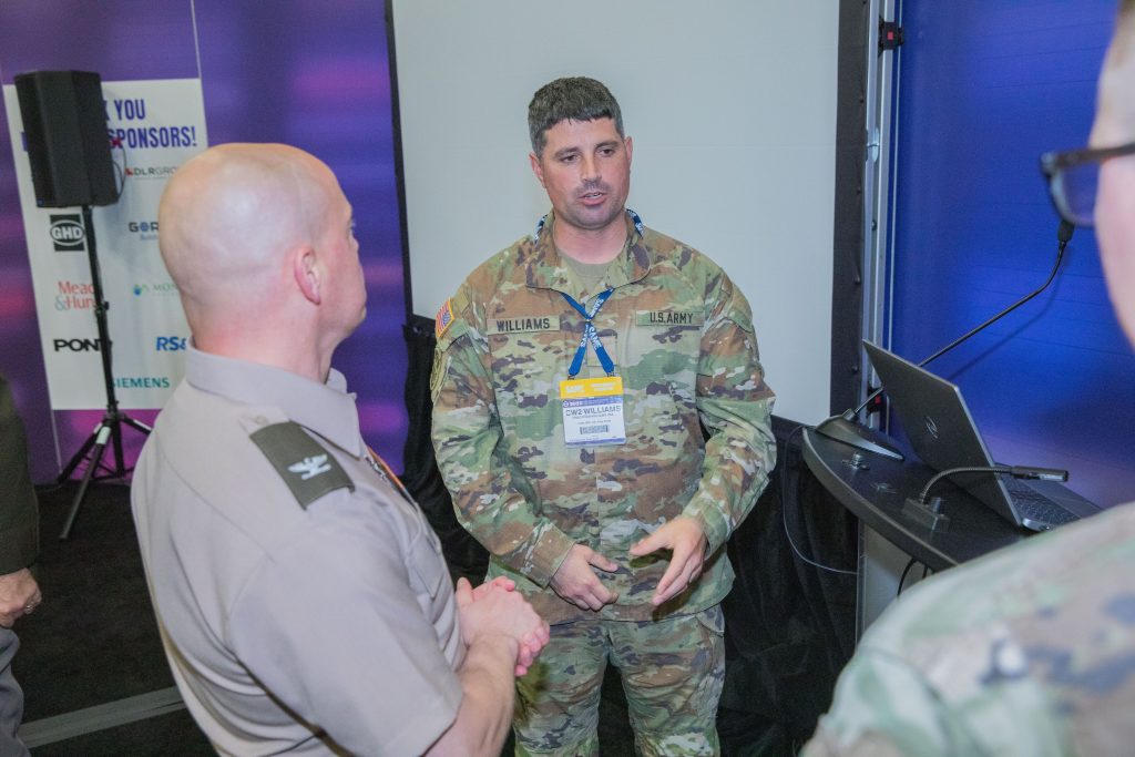
GeoWERX: GeoWERX is a live 3-day scenario driven demonstration executed annually during the Joint Engineer Training Conference & Expo (JETC). The goal of this event is simple- expand awareness and leveraging of geospatial engineering capabilities for better informed decisions, actions, and outcomes for all engineering missions. Deeds, not words.
GeoWERX III – JETC 2023, San Antonio, Texas
- GeoWERX III (Story Map)
- GeoWERX III (Video)
- In Focus: Managing Assets at JETC (Article)
GeoWERX II – JETC 2022, Aurora, Colorado
- GeoWERX II (Story Map)
- GeoWERX II Geospatial Solution (Video)
- GeoWERX II – a Geospatial Engineering Demonstration at JETC (Announcement Video)
GeoWERX I – JETC 2019, Tampa, Florida (Video)
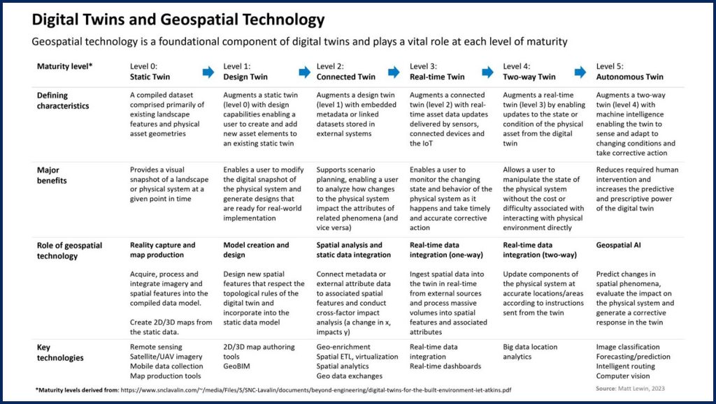
The Past and Future- Digital Twin: Pursuit of infrastructure Digital Twins has a very long history, but modern interests have been ignited by continued and sustained advances in technologies making them more accessible. The power of these types of capabilities are currently only limited by imagination and available resources; their potential return on investment- staggering. From traditional survey, BIM/ CAD, cartography, and GIS to Digital Twin, High-Definition Survey (HDS), sUAS, AI/ ML/ AR and beyond geospatial engineers continue to excel, showing the way!
The key is to think about geospatial technology not as playing one particular role but as adding unique capabilities and progressively more value at different stages of the digital twin journey.
- National Institute of Building Sciences Digital Twin Integration Sub-Committee
Education Partnership: SAME has entered a partnership with Bootcamp GIS to offer our members the latest program of geospatial industry short courses. Engineers, planners, and environmental scientists can elevate their skills in the growing $18B Geographic Information System industry. As a Subject Matter Expert platform, our members can apply to author a course or sign up as a student to learn applied skills. You can take an individual course or earn a GIS certificate by taking six courses in six months.
SAME National Webinars
-
- Webinar
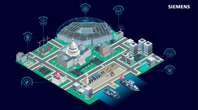
Understanding to Action: Smart Infrastructure within the Federal Government
In the rapidly evolving landscape of technological advancements, our presentation offers a unique look into the world of smart infrastructure and government facilities. Far more than a discussion, this session is an exploration for those seeking a deeper understanding of the latest innovations that are reshaping the smart infrastructure market. -
- Webinar
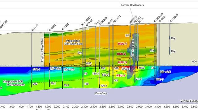
Environmental Sequence Stratigraphy in Practice
Environmental Sequence Stratigraphy (ESS) utilizes nearly 75 years of academic and industry science to develop more effective ways to characterize the distribution of geologic materials in the subsurface. ESS technology helps to better understand contaminant migration and constrain flux-based conceptual site models. With roots in sedimentology, stratigraphy, and basin analysis, the oil and gas industry has used ESS to better understand and predict reservoir conditions, enabling more effective reservoir development. However, using similar approaches in these sites is proving trickier because direct technology transfer is difficult in characterizing contaminated aquifers. -

- Webinar
EV Charging Considerations for Power System Studies
Power system studies generally focus on power distribution equipment and often do not consider individual building loads. As electrical vehicle (EV) charging becomes more common, a Short Circuit, Coordination and Arc Flash Analysis may need to consider EV equipment in order to evaluate short circuit ratings of equipment, size new and existing circuit breaker protection, and quantify electrical and arc flash hazards. -
- Webinar
Public-Private Partnership (P3) Opportunities for Fed Energy and Sustainability Projects
The Federal Government of the United States, as the country’s largest real property asset holder, oversees approximately 500 million square feet of built environment.