

Webinar | How Global Flood Data Drives Infrastructure Resilience and Emergency Management
Wednesday, January 13, 2027 | 1:00 p.m. – 2:00 p.m. ET
*Webinar is free for all attendees
About the Webinar
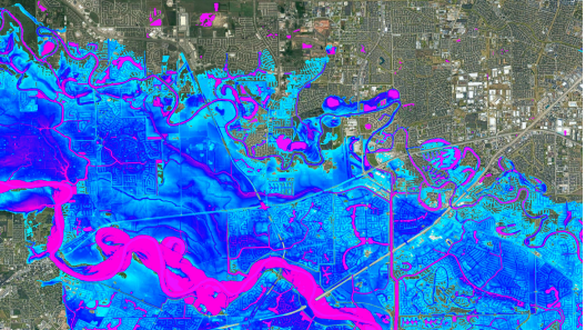
The national security landscape must go beyond static maps and embrace flood data when planning infrastructure resilience and emergency managements investments and strategies. Today, military bases, government facilities, and critical infrastructure all face escalating threats from flash river and coastal flooding. However, traditional regional flood maps often lack the global coverage, high resolution, and future condition projections needed to evaluate site-specific vulnerabilities accurately.
This webinar will demonstrate how physics-based 2D hydraulic modeling and climate-conditioned flood datasets can deliver actionable and scalable risk intelligence. Attendees will explore real-world case studies highlighting how engineering teams and federal agencies use global flood data across the entire asset lifecycle including; global portfolio risk assessments; national catastrophe modeling and actuarial risk; and emergency management and tactical response.
Learning Objectives
- Evaluate future flood exposure beyond static regulation.
- Identify the key coverage, scale and age limitations of traditional statutory flood hazard maps and explain the advantages of supplementing regulatory views with climate-conditioned 2D hydraulic modeling for long-range planning.
- Apply large-scale flood models across international engineering and emergency management workflows.
- Analyze real-world applications of global flood intelligence, from overseas diplomatic site evaluations and federal facility acquisition to national insurance catastrophe modeling and emergency response operations.
- Interrogate flood model reliability using key technical criteria.
- Formulate critical questions to evaluate model trustworthiness, examining underlying terrain resolution, river channel representation, flood defense assumptions, pluvial peril inclusion and methodology transparency.
Presenter
- Gavin Lewis,Head of Engineering and Public Sector, Fathom
Moderator
- TBD
Hosted by the SAME Resilience COI
For registration questions or issues, contact registration@same.org.