Contributed by David Foster, Founder and Owner 372 Consulting
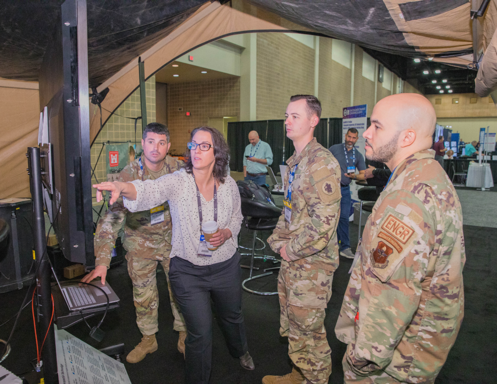
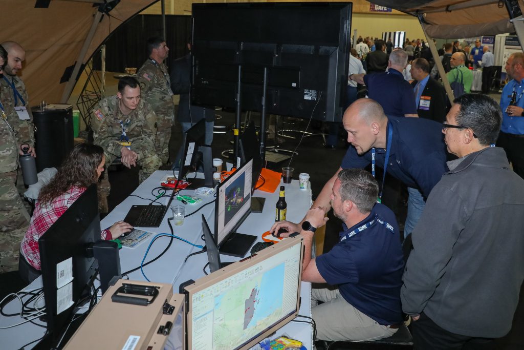
The Geospatial Working Group Demonstrates the “Silent Function” at JETC 2024.
At the upcoming Joint Engineer Training Conference & Expo, SAME’s Geospatial Working Group will offer an expanded slate of programming and opportunities for attendees looking to dive into the diverse discipline of geospatial engineering.
In addition to the return of its successful GeoWERX demonstration—an interactive event on the exhibit floor at JETC that will provide an opportunity for attendees to engage with geospatial engineering experts and discover the full capabilities of Geospatial Engineering—the working group will also bring roundtable discussions and educational programming to engage attendees across the geospatial engineering community. While the term “geospatial engineering” is often associated with cutting-edge technologies such as digital twins, it actually covers a much wider field of capabilities, and this year’s offering at JETC reflect the diversity of disciplines and roles within this field.
The Silent Function
No matter what comes next, the evolution of the information age and warfare itself demands military engineers treat data as a weapon system and manage, secure, and use data for operational effect.
Today’s U.S. military engineering culture embraces two main functions. The first function can generate the body-jarring overpressure of explosives, teeth-rattling vibrations of armored vehicles and heavy equipment, hypnotic hammering of nails, and ear ringing symphony of saws cutting wood. The results of these capabilities in action are tangible and easy to see, smell, and touch. Conversely, the same engineering culture has had difficulty embracing its second main function. It is relatively silent, less tactile, often unseen, and punctuated by the shimmering lasers of remote sensing equipment, gentle stroking of keyboards, and mesmerizing hushed hum of servers and plotters, ultimately resulting in information and products enabling engineer missions and those of joint forces they support.
This is a modern and somewhat confusing quandary. For centuries, location-centric hard copy (physical) products created by topographers, surveyors, geographers, draftsman, and even architects were iconic symbols of great military engineering feats. Today, however, the preponderance of products generated by these engineers comes in digital forms. Yet, whether hardcopy or electronic, these products provide context for common understanding of complex operating environments on which critical engineering decisions are made and actions taken.
This “silent function” geo-enables and integrates data, generates decision support products, and provides services that contribute to the digital foundation for operations across basing, contingency, and warfighting domains.
Geospatial engineering is a doctrinal function of the military engineer and plays a pivotal role in enhancing decision-making processes for urban planning, environmental management, transportation systems, and battle spaces by providing accurate and timely geospatial information. With such broad responsibilities, geospatial plays a role in all military engineering initiatives.
Digital Possibilities
For military engineers looking forward at the possibilities beyond the Information Age, the promise of built and natural infrastructure digital twins capabilities that generate, analyze, visualize, and direct actions based on data generated by the infrastructure itself is exhilarating to think about. However, like other capabilities employed by the military, understanding and mitigating costs and associated risks must be considered at great length.
No matter what comes next, the evolution of the information age and warfare itself demands military engineers treat data as a weapon system and manage, secure, and use data for operational effect. Regardless of their functional focus, they must be savvy in digital capabilities that generate accurate and complete data and those that make these data visible, accessible, understandable, linked, trusted, interoperable, and secure. They must also be agile and be able to rapidly adapt to ever-changing digital environments and processes driven by technological advancements.
Whether in support of strategic planning, managing installation built and natural infrastructure, conducting disaster response, or providing mobility, counter-mobility, survivability capabilities for maneuver forces, or any other number of missions, digital warriors of the geospatial engineering community will“show the way.” Although it may not make much noise or directly change a physical landscape like their sister functions, the impact of the silent function enabling the decision advantage are immense.
Opportunities to Get Involved at JETC
The Department of Defense’s (DOD’s) ability to rapidly adopt new capabilities and keep pace with modern advancements is constrained by law. Industry partners are not so constrained, and thus their ability to rapidly acquire, evaluate, and deploy digital capabilities far exceeds DOD’s. This creates an opportunity for the government to learn from their industry mission partners, adopting best practices when appropriate, all while reducing potential risks with measured approaches.
SAME’s GWG is one of those mission partners. GWG continues to actively coordinate activities expanding awareness and leveraging of geospatial engineering capabilities for operational effect. In 2024, the annual capstone of these efforts will take place during JETC in Orlando, Fla., where three important events are planned.
- Geospatial Government Roundtable. The roundtable will focus on discussions on implementation of Joint Operational Engineer Board FY23 Work Plan Focus Area #7, challenges, recommendations, and increased DOD geospatial engineering professionals in SAME activities.
- GeoWERX ’24: A live, three-day demonstration of modern engineering practices held on the Exhibit Hall floor.
- Installation Geospatial IGG Quarterly Meeting. A meeting of the DOD Installation Geospatial Information and Services Governance Group.
For more information on these events and how to participate during your time in Orlando, visit the JETC webpage.
Bettering our Support for National Objectives
The impacts of built and natural infrastructure, natural phenomena, human activity, and their interaction are significant considerations for military operations. The ability to shape and sustain the effects of these infrastructures are critical to achieving strategic, operational, and tactical goals and objectives. Often behind the scenes, geospatial engineers assist everyone’s understanding of complex operating environments, leading to more effective and efficient mission execution. Getting to know the silent function and embracing it will dramatically amplify the positive engineering effects of all three engineering functions bolstering DOD’s support of national objectives.
Share Your Expertise With SAME
SAME invites A/E/C and related industry professionals, academics, uniformed servicemembers, and government leaders to submit news articles sharing their insights and thought leadership on timely topics. Read our Writer’s Guidelines and submit your own article for consideration at the links below.
-

Guest Post: Prioritizing the Warfighter Executive Order – How A/E/C Government Contractors Should Respond
Deltek provides clarity on the recent executive order “Prioritizing the Warfighter in Defense Contracting” and its implications for defense contractors in the A/E/C industry. -
Guest Post: The Top Federal Opportunities for FY2026 in the Government Contracting Market
Deltek outlines the top federal opportunities for FY2026 and provides in-depth analysis for the government contracting market. -
Guest Post: Navigating Federal Procurement Shifts: What A/E/C Firms Need to Know
Deltek examines how Federal procurement reform is reshaping the contracting environment for every business that sells to the government. Understanding the implications of these changes are critical to delivering effective services to federal clients.